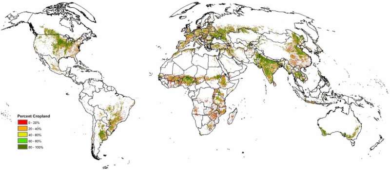
To address the needs of the agricultural monitoring community, IIASA scientists fused two of the latest high-quality, high-resolution, remotely sensed cropland products to produce an improved cropland map for early warning and food security assessments.
To ensure efficient resource management, food security, and environmental policies, policymakers require the most sophisticated and up-to-date information about agricultural areas. This information is typically derived from satellite observations of our planet.
Scientists tend to compile such data into cropland maps to make it more comprehensive, so it can be used for tracking crop production, developing sustainable agricultural practices and supply chains, as well as assessing land use changes.
The increasing frequency and severity of droughts and other extreme weather events caused by climate change makes accurate mapping of cropland areas increasingly important, since drought-induced production losses can heavily impact the global market.
To further improve the accuracy of the existing data, researchers from IIASA and the European Commission’s Joint Research Center have developed a new global hybrid cropland map, which can help to conduct more rigorous agricultural monitoring and food security assessments. The research is published in the journal Environmental Research Letters.
The map was created by combining two of the latest cutting-edge remotely-sensed products: the European Space Agency’s WorldCereal system and the University of Maryland’s Global Land Analysis & Discovery (GLAD) cropland layer. These datasets were fused at a 500-meter resolution, allowing for a more detailed representation of cropland distribution worldwide.
“Our primary aim was to integrate two of the most recently available and accurate cropland products into a hybrid cropland map,” explains Steffen Fritz, IIASA Strategic Initiatives Program Director, a researcher in the Novel Data Ecosystems for Sustainability Research Group, and the lead author of the study.
“This helped us to further improve findings about the areas where individual cropland maps disagree using visual inspection using the Geo-wiki toolbox by experts, who decide which of the maps better captures the cropland extent and then correct the hybrid map accordingly.”
To address inconsistencies between the two datasets, researchers identified “hotspots of disagreement”—areas where the maps significantly differed either in the percentage of cropland or in the presence or absence of cropland.
Experts manually corrected these discrepancies using the Geo-Wiki validation tool. Geo-Wiki is a platform designed by IIASA as an interactive, online space that allows volunteers (citizen scientists) to visually interpret satellite images and validate or correct land cover maps in order to improve global land cover and land use information.
The final hybrid map was validated through a process involving visual interpretation of a selected sample. This validation confirmed that the new map not only improves the overall accuracy of cropland data, but also provides an improved spatial representation of cropland in critical food insecure areas to be used in early warning systems, regional agricultural monitoring, and food security assessments.
The enhanced map is expected to play a role in improving the reliability of global agricultural monitoring in the field of food security.
A modified version of this hybrid map is now being used by the Anomaly Hotspots of Agricultural Production (ASAP) of the European Commission as a baseline cropland mask for early warning and food security monitoring.
More information:
Steffen Fritz et al, A new global hybrid map of annual herbaceous cropland at a 500 m resolution for the year 2019, Environmental Research Letters (2024). DOI: 10.1088/1748-9326/ad6a71
Citation:
Improving the accuracy of global cropland mapping (2024, August 22)
retrieved 22 August 2024
from https://phys.org/news/2024-08-accuracy-global-cropland.html
This document is subject to copyright. Apart from any fair dealing for the purpose of private study or research, no
part may be reproduced without the written permission. The content is provided for information purposes only.
